A turn-by-turn navigation system is a combination of hardware and software that provides an automobile driver with one or more motorable routes between Point A and Point B on the surface of the earth. Sold as a dedicated satnav system or as an integral part of a smartphone, it comprises the following building blocks:
- GPS. More precisely, GPS Receiver. GPS looks up a combination of four geostationary satellites and tells the “LatLong” i.e. latitude and longitude of the driver’s location on the surface of earth. The GPS system is owned by Department of Defence, USA. (According to some accounts, GPS also reports altitude but it’s supposed to highly inaccurate. We can ignore that since there’s no flying involved in the present context!)
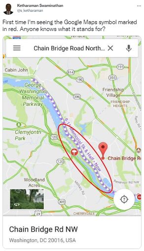 Map. It shows roads, buildings, water bodies, bridges, tunnels and other attributes of the terrain. Despite asking around, I haven’t been able to figure out what some attributes stand for, like the one shown on the exhibit in the right. High end maps also contain information regarding speed radars, gas stations, and rest areas on the way.
- Algorithm. This is the software program that computes the route from starting point to the ending point, projects it on the map, gives audio cues to the driver as s/he reaches every turn, and tells him or her whether to turn left, turn right or go straight. Ergo the expression “turn-by-turn navigation”. Starting point is where the GPS is situated. Ending point is the destination that’s manually entered by the driver at the start of the journey. The algorithm works by finding all available pathways and their “quantity” and “quality”. “Quantity” is a fairly straight forward geometrical calculation based on interconnection of motorable roads, bridges over waterbodies on the way, tunnels through mountains, and so on. Quality takes into account speed limits, traffic disruptions caused by accidents, lane closures, and other parameters that are obtained from other smartphones or drivers on the route via Mobile Internet or dedicated FM frequencies respectively, as described in How Does Google Maps Know About Traffic Conditions In Realtime? Since there could be multiple routes between any two points, the algorithm computes and displays all available routes, and either lets the driver select one manually, or computes the “best route” based on fastest route, route with the least toll, and other “constraints” specified by the driver.
When these three components work together, the driver gets a motorable route between point A and point B.
People colloquially refer to turn-by-turn navigation as just “GPS” (or “Map” or “SatNav”). Which one in specific depends on the predominant brand involved e.g. Garmin GPS (or Google Maps or TomTom SatNav).
This tends to convey the impression that it comprises just one of the three components. That’s not true. Turn-by-turn navigation is a combination of all three building blocks.
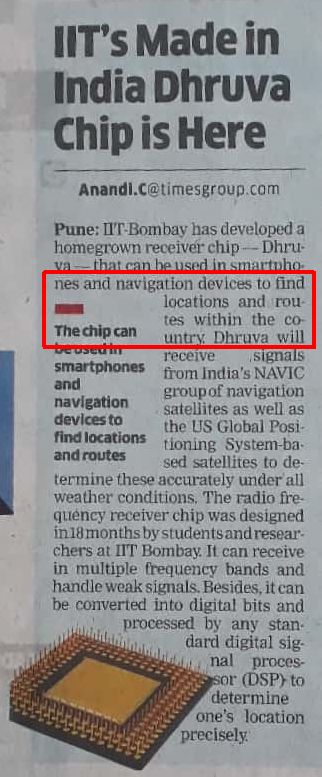 IIT Bombay recently launched a chip called Dhruva. Please see exhibit on the right for details.
The article says Dhruva can find locations and routes.
If Dhruva has GPS, it can obviously find locations.
But if Dhruva can also find routes, then it must be having embedded maps and algorithms to compute the “quantity” and “quality” of pathways. In that case, it’s a fully fledged “Turn by Turn Navigation System in a Chip”, not a mere chip.
If so, it could be a highly disruptive product and needs to be marketed aggressively.
From my IITB alumni circles, I was able to informally gather the following clarifications.
- Dhruva is only a GPS chip. There are a plethora of GPS chips in the market but Dhruva differentiates itself by being the only one that can receive signals from India’s NAVIC group of navigation satellites.
- None of the other GPS chips in the market support NAVIC. So, for India to extract any value from NAVIC, it needs a GPS chip that supports NAVIC. Dhruva fits the bill.
- Apparently, Dhruva will be made mandatory for all smartphones, smartwatches and other navigation devices sold in India. If so, it will enjoy a huge captive market right off the bat.
I have reached out to my alma mater for confirmation of the grapevine and I will update this post when I hear back.
UPDATE DATED 31 MARCH 2022:
In the last two years after the original post was published, I have not heard anything more about Dhruva or NAVIC. I don’t know of any announcement making Dhruva mandatory for all smartphone and other navigation devices sold in India. AFAIK, all of them continue to use the same combination of GPS, Map and Algorithm that they have used in the past.